Search...
Overview

Our client specializes in capturing infrastructure objects and developing detailed digital models using real textures extracted from drone-captured images. These models serve as essential documentation, enabling the identification of damages such as cracks, corrosion, or structural wear. These digital representations facilitate the creation of comprehensive building inspection reports, which in turn help develop the best reconstruction strategies and maintenance plans.

To capture the infrastructure in detail, the team employs photogrammetry technology using drone-captured imagery. This approach was selected due to the limited accessibility of certain areas with traditional scanning devices or digital cameras.

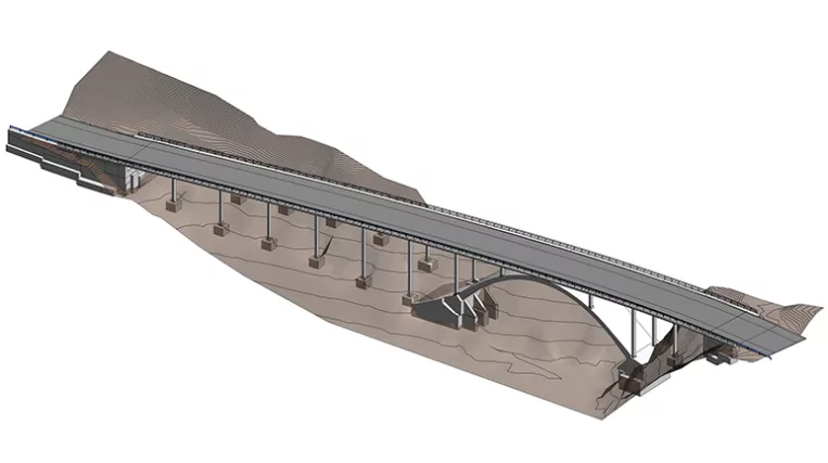
Scope of work: Precise modeling of the concrete girder bridge and the adjacent ground surface.

Input: Full point cloud of the bridge and adjacent area obtained through photogrammetry (drone capture).

Output: 3D model of the bridge in LOD300.

Services: BIM, STRUCTURE
Subservices: Scan to BIM
Industry: Infrastructure
Object type: Bridges
Area: 3200 m² / 34450 ft²
Tools used: Autodesk Revit, Autodesk ReCap
Share:
Project stages
1. Receiving input
2. Analyzing the input, requesting additional information, and selecting the optimal team structure
3. Preparation for modeling, including building a network of reference planes for bridge segmentation
4. Modeling the bridge surface and its supports
5. Adding all identifiable MEP elements
6. Quality control process
7. Project support
1

Modeling features

Bridges present unique challenges compared to traditional buildings due to their non-orthogonal shapes, curvatures in plan view, and elevation changes in side views. As a result, standard Revit tools are insufficient for modeling such complex surfaces.

To address this, our team developed an approach involving the creation of cross-sectional outlines at intervals along the bridge. Using Revit’s mass tool, they generated smooth, curved surfaces that pass through these cross-sections, enabling accurate representation of curved elements. This approach simplifies the later application of real textures.

Point cloud vs Model

Project challenges

While drone-based photogrammetry offers many advantages, such as ease of access to remote areas and cost-efficiency, the data often requires significant refinement. Post-processing typically reveals noisy point cloud data, where points may be scattered or surfaces poorly defined, adding complexity to the team’s workflow as they determine the most effective way to structure the model.

Another frequent issue is data duplication, where point clouds may overlap slightly or be misaligned. While the preferred solution is to request a new dataset from the provider, when this isn’t possible, the team manually evaluates and selects the best data set, though this may compromise precision in some cases.

1
Point cloud vs Model
Key requirements

To meet project objectives and prepare the model for future use, our team adhered to strict guidelines, including:

  • Ensuring all railing components were placed precisely in their real-world positions, essential for accurate texture mapping. In cases where post placement deviated from regular patterns, manual adjustments were made for each location.
  • Modeling distinct elements, such as edge beams, road surfaces, and decks, as separate entities with perfect alignment — no gaps allowed. Since point cloud data often couldn’t reveal the internal structure, any unseen sections were finalized in consultation with the client.
  • In some cases, client-supplied drawings provided additional insights, such as hidden structural features (e.g., segmented abutments or underground piles), which the team integrated into the model.
  • Finally, all model elements were exported in .ifc format to ensure compatibility for further processing.
Point cloud vs Model
Benefits
Utilization of advanced Revit tools for modeling curved elements
Combination of data from point clouds and client-provided drawings
Precise modeling for accurate real-condition texture application
Tools used
1
Autodesk Revit
1
Autodesk ReCap
view project view more view photos