
Top cases of using drones in construction for construction monitoring purposes
Outline:
- Introduction
- Drones in construction management as the technology frontier of construction site monitoring efficiency
- The benefits of drone technology for construction site monitoring
- Drones vs. traditional construction monitoring methods: the difference it makes
- Top 6 ways to utilize the capabilities of drones in construction
- Beyond basics: the advanced features of construction drones
- Key Takeaways
- About us
Introduction
In the dynamic realm of construction, the usage of drones in construction site monitoring holds a unique position, and for good reason. Since there is an urgent demand for more effective construction monitoring solutions, drones help construction projects usher in an era of efficiency, precision, and safety.
In this article, we’ll explore how construction project teams can leverage the capabilities of drones, highlighting their superpowers and the most impactful areas of use.
Drones in construction management as the technology frontier of construction site monitoring efficiency
Construction sites are notorious for going overtime and over budget. Consequently, it’s a headache for everyone involved – owners watching dollars fly, contractors facing frustrated clients, and workers scrambling to catch up. Above all, this inefficiency isn’t just annoying; it’s costly, slowing growth and hindering the industry’s potential.
According to a McKinsey Global Institute report, the construction sector suffers annual losses totaling a staggering $1.2 trillion due to inefficiencies and waste. Similarly, large construction projects often exceed their expected completion time by 20% and surpass budget estimates by up to 80%. Moreover, reliance on traditional methods, the lack of technological adoption, and insufficient operational transparency across a fragmented stakeholder landscape contribute to the problem.
These inefficiencies can certainly be justified. After all, the complexity of construction projects is staggering, and the site monitoring process involves various considerations. For example, the challenging aspects include integrating diverse monitoring technologies and handling large volumes of data. Ensuring regulatory compliance, managing remote locations, and addressing environmental and security challenges are other impactful factors that must be considered.
The benefits of drone technology for construction site monitoring
Drones can be a game-changer for construction site monitoring operations in this diverse array of tasks. Undoubtedly, this technology can significantly contribute to streamlining processes and enhancing project management capabilities. Moreover, it has already demonstrated a proven track record in doing so.
Let’s take a look at a few impressive examples from construction drone adoption:
- The Balfour Beatty and Vinci, the leading joint venture in delivering critical infrastructure, projected annual savings of £50,000 due to using drones in construction for quicker and more cost-effective site surveys.
- The Norwegian Public Roads Administration experienced significant time savings by utilizing drones. In fact, depending on the project scope, they reduced field time from 5 days to 15-60 minutes.
- Drones in construction monitoring contributed to a 61% improvement in data quality, as stated by DroneDeploy.
- Above all, the impact of drone technology on the construction and manufacturing sector in the UK, according to a PwC report, is projected to result in cost savings of £1.6 billion by 2030.
And this is just the beginning.
In addition, drones offer unique advantages such as aerial perspectives, mobility, and data collection capabilities that provide comprehensive insights into construction site activities, progress, and safety conditions.
Beyond time efficiency, cost savings, data quality, and other above-mentioned qualities, drone technology delivers the following value for construction monitoring:
- Enhanced safety of construction workers. First of all, drones can access hard-to-reach or hazardous areas. Therefore, they reduce the exposure of workers to be exposed to potential risks.
- Unprecedented data transparency through real-time construction time security monitoring. The use of drones in construction enables real-time updates and high-resolution images. Thanks to them, project managers can monitor progress efficiently and identify issues in no time.
- High accuracy in collected data. Primarily, drones are known for capturing high-resolution imagery and collecting data with exceptional accuracy. Hence, this level of detail helps optimize construction processes, enhance safety measures, and improve overall project management efficiency.
- Flexibility for rapid, hassle-free construction site inspections. Drones can swiftly navigate construction sites and provide real-time data and imagery. Subsequently, it empowers project managers and engineers to identify issues promptly and make informed decisions.
- Improved alignment between various stakeholders and internal teams. Last but not least, drone-captured images and videos facilitate better communication among stakeholders, including architects, engineers, and clients. Hence, it leads to higher efficiency and more informed decision-making.
Drones vs. traditional construction monitoring methods: the difference it makes
The evolution of construction monitoring methods has significantly shifted from traditional manual approaches to more advanced and technology-driven solutions. Initially, construction site monitoring relied heavily on manual labor, visual inspections, and paper-based documentation. These factors led to critical gaps that hindered informed decision-making about project progress, safety risks, and potential issues. Ultimately, these data gaps resulted in delays, cost overruns, and compromised project outcomes.
Due to the advent of technology, the approaches to construction monitoring have become way more sophisticated and efficient. Undoubtedly, the emergence of drones in construction sites vastly contributes to that. So, what are the key differences between conventional and innovative construction monitoring methods and their capabilities? Let’s explore.
| Aspect | Traditional Monitoring | Drone Monitoring |
| Process Execution | Slow, manual collection | Real-time monitoring, swift decisions |
| Data Accuracy | Variable, prone to error | Highly accurate, aerial imagery |
| Coverage Area | Limited by accessibility | Extensive, including hard-to-reach areas |
| Progress Visualization | Static images, reports | Dynamic aerial imagery, 3D models |
| Adaptability | Limited adaptability | Real-time adjustments |
| Environmental Assessment | Limited capability | Comprehensive monitoring |
| Cost | Higher, labor-intensive | Reduced costs, initial investment |
As demonstrated in the table above, drone monitoring offers significant efficiency, accuracy, adaptability, and cost-effectiveness advantages compared to traditional construction monitoring methods. Importantly, these capabilities gain vast recognition from forward-thinking players in the construction domain, ranging from industry giants like Bechtel and Skanska to renowned brands such as Shell, BMW, and Ford.
Top use cases of drone technologies in construction site monitoring
| Site planning and surveying | Environmental assessment | Risk assessment and mitigation | Construction site real-time monitoring |
| Progress reporting | Visual inspections | Inventory management | Resource utilization efficiency tracking |
| Preventive maintenance | Quality control & assurance | Safety compliance | Efficient construction site documentation management |
Top 6 ways to utilize the capabilities of drones in construction
Embracing the capabilities of construction drone technology entails understanding its offerings and optimizing its use across various stages and domains of the construction monitoring process. So, let’s navigate through this landscape of capabilities together.
3D mapping and modeling through photogrammetry
Visualizing the site, analyzing topography, and tracking progress over time — all of these can be seamlessly achieved with the assistance of unmanned aerial vehicles (UAVs), otherwise known as drones. Since they are equipped with multi-purpose cameras and LIDAR sensors, LIDAR drones can instantly capture high-resolution images and data from the site.
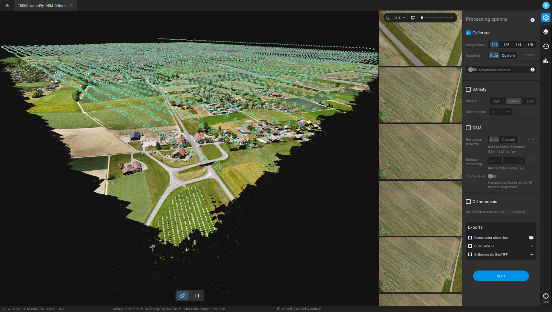
An example of photogrammetry software. Source: GISGeography (gisgeography.com)
Once the drone captures the images, a special drone photogrammetry software processes them, utilizing overlapping images to create exact 3D models of objects and terrain. Therefore, these models accurately represent surface geometry and spatial information, while texture mapping techniques provide realistic visual textures to the model.
Aerial photography
Construction drone photography allows for elevating construction monitoring to a whole new level, metaphorically and literally.
Their ability to capture aerial shots makes inspecting roofs, facades, and scaffolding effortless and risk-free. Consequently, this approach prioritizes the team’s safety and minimizes potential hazards for workers.
High-resolution imagery and videos captured by drones serve as valuable documentation for project management, client updates, and regulatory compliance. Furthermore, they have versatile applications throughout the project lifecycle, from site assessment to planning and design phases.
Topographic mapping (Digital Terrain Modeling)
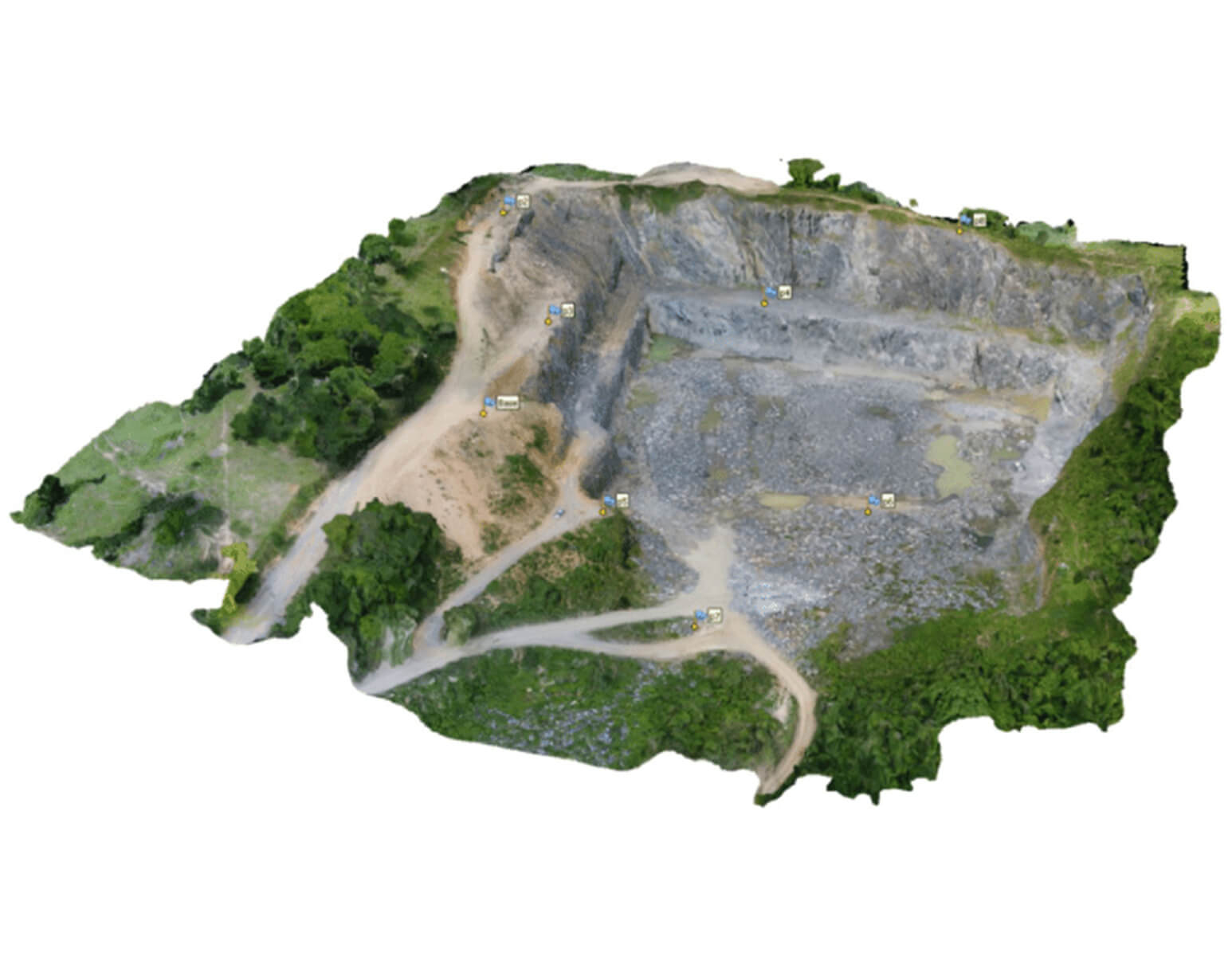
A Digital Terrain Model (DTM) captured by a drone at an altitude of 80 meters. Source: ResearchGate (researchgate.net)
Post-flight image processing and point cloud generation create a digital terrain model (DTM) — a digital representation of the terrain’s surface with contour lines displaying data on the Earth’s surface elevation.
By accurately depicting the elevation and contour of the construction site, the DTM provides valuable insights into its topography. For example, this insight-packed data includes elevation variations, slope analysis, environmental considerations, potential safety hazards, identification of possible access points and routes for construction vehicles and equipment, and many more.
Moreover, using a drone for mapping enables engineers and planners to design drainage systems strategically that mitigate the risk of flooding, erosion, and water accumulation. Additionally, it allows for identifying potential drainage bottlenecks and optimizing infrastructure placement, thereby improving overall site resilience and long-term functionality.
Thermal imaging by drones
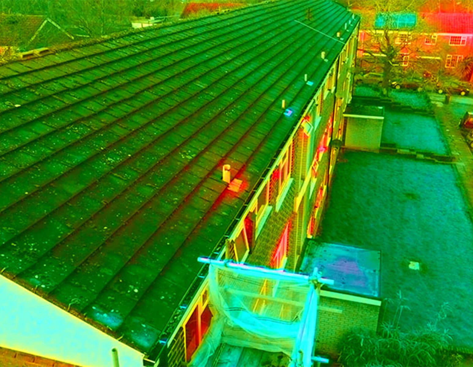

Representation of a thermal image captured by a drone. Source: Man With a Drone (manwithadrone.net)
Drones equipped with a thermal camera can detect heat signatures emitted by objects. Thanks to it, it is possible to access and analyze the visualizations of temperature variations across the site in the format of color-coded images or thermal maps. Ultimately, this data can reveal a lot to the trained eye of an expert construction planner or engineer.
Thermal imaging enables the identification of anomalies such as hotspots, cold spots, or temperature differentials across the construction site. These anomalies may indicate overheating equipment, energy inefficiencies, insulation problems, or potential fire hazards.
Lastly, monitoring temperature variations and changes over time can facilitate proactive maintenance, enabling early detection of potential issues, faults, or malfunctions to schedule repairs accordingly.
Multispectral imaging by drones
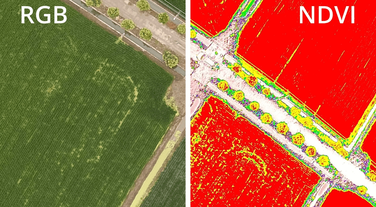
An example of a multispectral image. Source: Heliguy (heliguy.com)
Multispectral imaging by drones takes construction monitoring to the next level. It provides valuable insights into vegetation health, soil composition, and moisture levels. Besides, multispectral imaging allows for considering a range of environmental factors such as water quality, pollution levels, and other habitat conditions. Consequently, this provides better-informed grading, drainage, and erosion control decisions.
Volumetric measurement
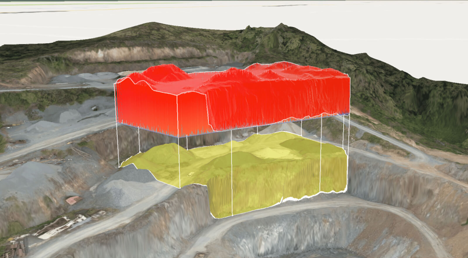
Volumetric analysis by a drone. Source: PropellerAero (propelleraero.com)
Volumetric measurement by drones for construction monitoring involves utilizing UAVs equipped with specialized cameras and sensors to calculate the volume of materials such as Earth, gravel, or stockpiles on the construction site.
Therefore, by leveraging this technology, construction teams can optimize resource management, track project progress, and ensure efficient and cost-effective construction operations. Additionally, it facilitates quality control by identifying discrepancies between planned and actual material quantities — material loss, theft, or inefficiencies in construction processes.
Beyond basics: the advanced features of construction drones
| Intelligent route planning | Obstacle avoidance | Durability and weather resistance | Autonomous operation |
| Automated flight Reports | Side-to-side data comparison | Real-Time video streaming | Integration with construction and project management software |
Key Takeaways
Undoubtedly, the drone construction industry will continue revolutionizing the market as an indispensable tool in construction projects. Thanks to the ability to replace hours of on-site manual work by covering vast areas in minutes, generating real-time 3D models, and tracking progress instantaneously, the use of drones in construction unlocks versatile opportunities that extend way beyond site assessment and monitoring. In-depth inspections and insightful construction reporting, risk mitigation, safety assessments, and cost efficiency make this technological marvel indispensable in modern construction practices.
About us
ORIGIN is a transparent, efficient, and reliable partner with a vision to eliminate distances and borders in the AEC industry. Leveraging our profound industry expertise in complex AEC projects, we aim to set new efficiency, innovation, and technological adoption standards.
